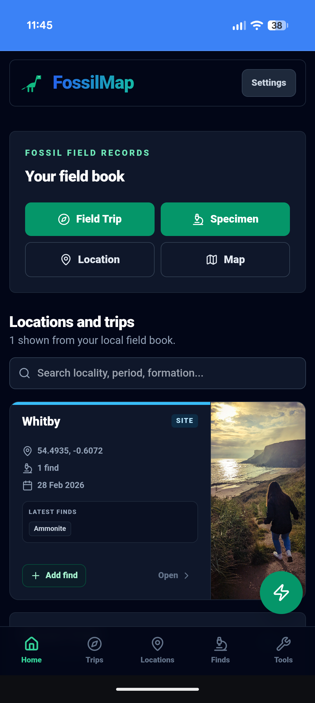
Field dashboard
Trips, locations, finds, tools and backup in one local-first workspace.
Record your finds. Preserve what matters.
Capture GPS, photographs and geological context in the field. Build a collection you can be proud of and contribute to the UK's growing fossil record when you're ready.
FossilMap helps collectors record better finds. FossilMapped helps shared records become useful research data.
Free · No account · Works offline · Your data stays on your device
Record privately first. Share only when you are ready.
FossilMap is built around how fossil recording actually works in the field. Start with a known locality or field trip, record specimens with GPS, photographs and geological context, then generate a structured field report when needed.
Simple enough for a first fossil. Structured enough to preserve useful scientific context.
Add a locality and let FossilMap automatically identify formation, period and geological context using British Geological Survey mapping.
Start a session at a locality. All finds recorded during the trip are linked to the session — building a full, dated field trip record.
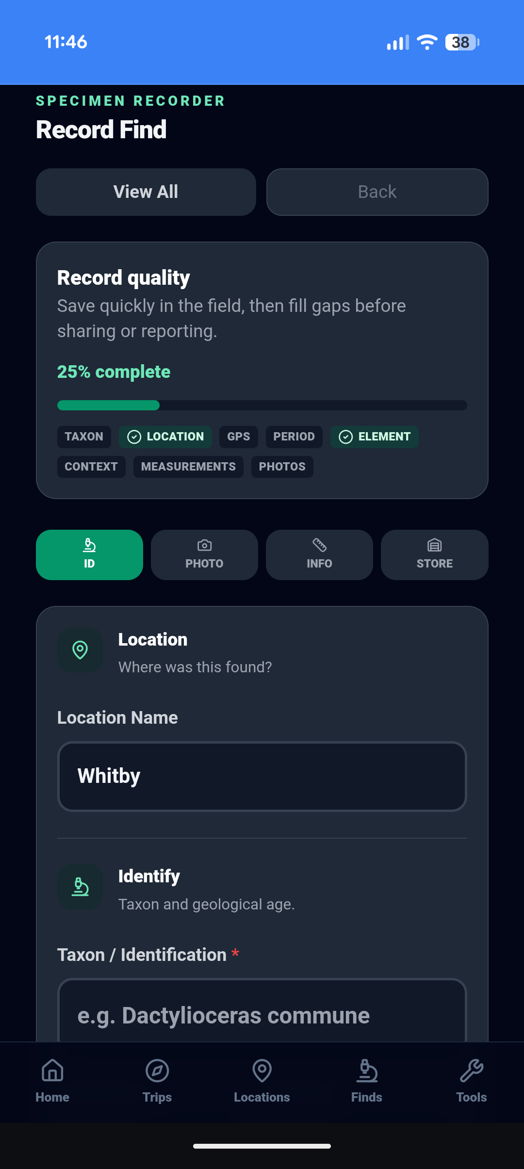
Quick GPS capture in the field. Add taxon, period, formation, photographs and taphonomy at the car or at home. Each specimen gets a unique reference code.
Generate a printable PDF field report. Export your full collection as a JSON backup. Share selected specimens to FossilMapped when your record is ready.
FossilMap helps you capture the details that are easy to forget in the field — not just the name of the fossil, but the place, photographs and geological context that make the record useful later.
Quality indicators help researchers see which records contain the strongest supporting information. FossilMap tracks completeness across the fields that matter most — so a record that includes GPS, taxon, formation, photographs and measurements is clearly distinguishable from one that does not.
Start a field trip, log finds as you go, check tides before you head to the foreshore, and export a structured PDF at the end of the day.
Open a session at a locality and add finds as you recover them. Notes, photographs and GPS — tied to the trip record in real time.
Know more than where a fossil was found. FossilMap can automatically identify the geological formation and age beneath your feet.
Print QR-coded specimen labels linked directly to the complete fossil record. No more mystery fossils in old trays.
One tap logs GPS position immediately. Add taxon, period and context later — at the car or at home. The location is never lost.
Generate a complete PDF from the session — suitable for club records, planning condition documentation or personal archives.
UK Environment Agency gauge readings built in. Know when the water turns — before you leave home. Includes foreshore safety guidance.
Recording where and how a fossil was found preserves information that can never be recovered once it's lost — and turns a personal find into a long-term record.
Once a fossil is removed without a record, that information is gone for good. GPS coordinates, formation and find context take seconds to capture in the field — but cannot be reconstructed afterwards.
Amateur collectors recover significant material from UK sites every year. Properly documented finds can help fossil groups, local recorders and future collectors understand what was found and where.
Collections change hands. Specimens are donated, sold, dispersed. A documented record — with specimen code, GPS, photographs and stratigraphy — survives the specimen itself.
More than a map. FossilMap helps collectors record better finds. FossilMapped helps those shared records become useful research data.
FossilMapped is not FossilMap with a different name. It's a separate research portal — a public database of shared UK fossil records, explored through a spatial map, record list, gallery and analytics dashboard.
Records only appear here when a collector deliberately chooses to share from FossilMap. Every shared find receives a permanent reference, a direct link and BibTeX citation tools for academic use.
Open Research Portal ↗FossilMapped is the public research portal for shared UK fossil records. Only records explicitly shared from FossilMap appear here — community-submitted, verified and research-grade finds from collectors across the country.
Nothing is shared automatically. FossilMap stores everything locally. Sharing to FossilMapped is an explicit, specimen-by-specimen choice — when the record meets your own standard.
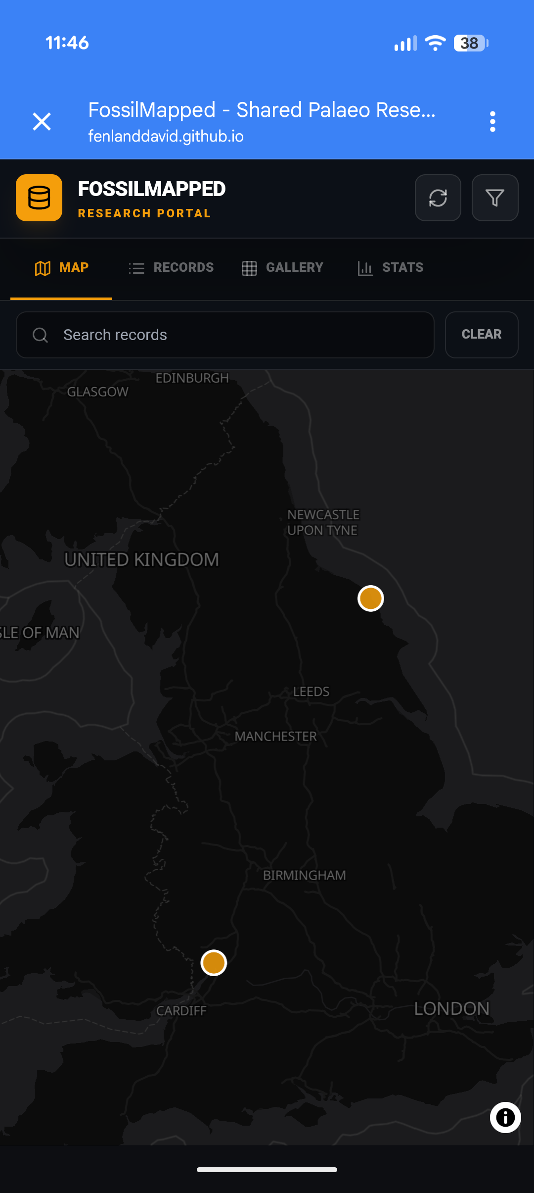
Every shared find starts as a Community record. Finds may advance to Verified or Research Grade through further review — visible through coloured badges on the map and record list.
Submitted by collectors and shared to the public fossil database. Visible to all, open for community engagement.
Orange marker on the map.
Reviewed and confirmed. Taxon, geological context and provenance have been checked by a trusted reviewer.
Green marker on the map.
High-quality records with confirmed locality, formation and element. Suitable for citation in published work. Exact coordinates visible to verified users.
Blue marker on the map.
Live counts from the shared UK fossil record. Growing with every collector who chooses to share.
FossilMap is being built by a small team with a shared passion for geology, palaeontology and responsible field recording. Our background combines practical collecting experience, fieldwork and an interest in preserving the context that gives fossil discoveries their long-term value.
Several members of the team have been involved in significant field work, including the excavation of the Rutland Sea Dragon and other specimens recovered across the UK. Those experiences have reinforced how important accurate provenance, geological context, photographs and field notes can be once a specimen leaves the ground.
FossilMap aims to create the UK's largest collector-generated fossil occurrence dataset, preserving provenance, stratigraphy and geological context that might otherwise be lost.
Our aim is to develop FossilMap and FossilMapped in partnership with universities, museums, geological societies and other professional organisations. Long term, we want the platform to become a trusted, Portable Antiquities Scheme-style route for the geology world: helping collectors record properly, share voluntarily and contribute useful data to research.
Everything you need to know before you install.
Yes — FossilMap is a Progressive Web App (PWA). On iPhone, open in Safari and tap Share → Add to Home Screen. On Android, your browser will prompt you to install. No App Store or Google Play required.
No. There is no account, no login and no email required. Everything is stored locally on your device. You can start recording immediately after installing.
Specimen recording, locality management, field trip tracking and collection browsing all work offline with no signal. Tide gauge readings and map tiles require a connection, but tiles are cached after your first visit to an area.
Yes. FossilMap captures period, stage, formation, member, bed, primary lithology, exposure type, element, preservation mode, taphonomy, find context, GPS coordinates and photographs — the details that make a fossil record useful long after the find is made.
FossilMapped is the public research portal for shared UK fossil records. It includes a spatial map, searchable record list, visual gallery, analytics dashboard, and CSV/JSON export. Shared fossils receive a permanent HRID reference, citation tools and BibTeX download. FossilMapped supports Community, Verified and Research Grade record tiers. Only records explicitly shared from FossilMap appear here — nothing is shared automatically.
When sharing a find to FossilMapped, you choose how precisely the GPS location is shown publicly: Exact GPS, ~100m area (recommended), ~1km area, or locality name only. The precision can be unlocked or relocked after sharing. Research Grade records show exact coordinates to verified users.
Use the backup export in Settings before switching. FossilMap exports your full record — all specimens, localities, field trips and photographs — as a JSON file that restores on your new device. Nothing is on a server, so the export is the only copy.
FossilMap is an independent platform. If you are a researcher, museum or institution interested in the dataset or a formal partnership, please use the contact page.
Whether this is your first find or your five-hundredth, the record you build today is the one that lasts — for your own collection, and potentially for science.
No account. No subscription. Your data stays on your device.
Record privately first. Share only when you are ready.